
R&R SERVICES
APPLYING PRINCIPLES + PRACTICES
Whether it’s completing a survey to meet a closing date or expediting the approval process, we combine experience and technology to deliver cost and time efficiencies.
LAND SURVEYING SERVICES
-
3D Laser Scanning use the Trimble X7 to capture high-definition 3D point clouds with speed and precision. This cutting-edge tool integrates seamlessly with AutoCAD, Revit, and BIM software—saving time and reducing rework through accurate, design-ready data.
Aerial Photogrammetry uses our DJI Mavic 3 drone, we collect precise aerial imagery to create 3D models, topographic maps, and elevation data. Ideal for large or complex sites, this method enables efficient measurement, monitoring, and mapping from above.
Discover how aerial photogrammetry can elevate your next project.
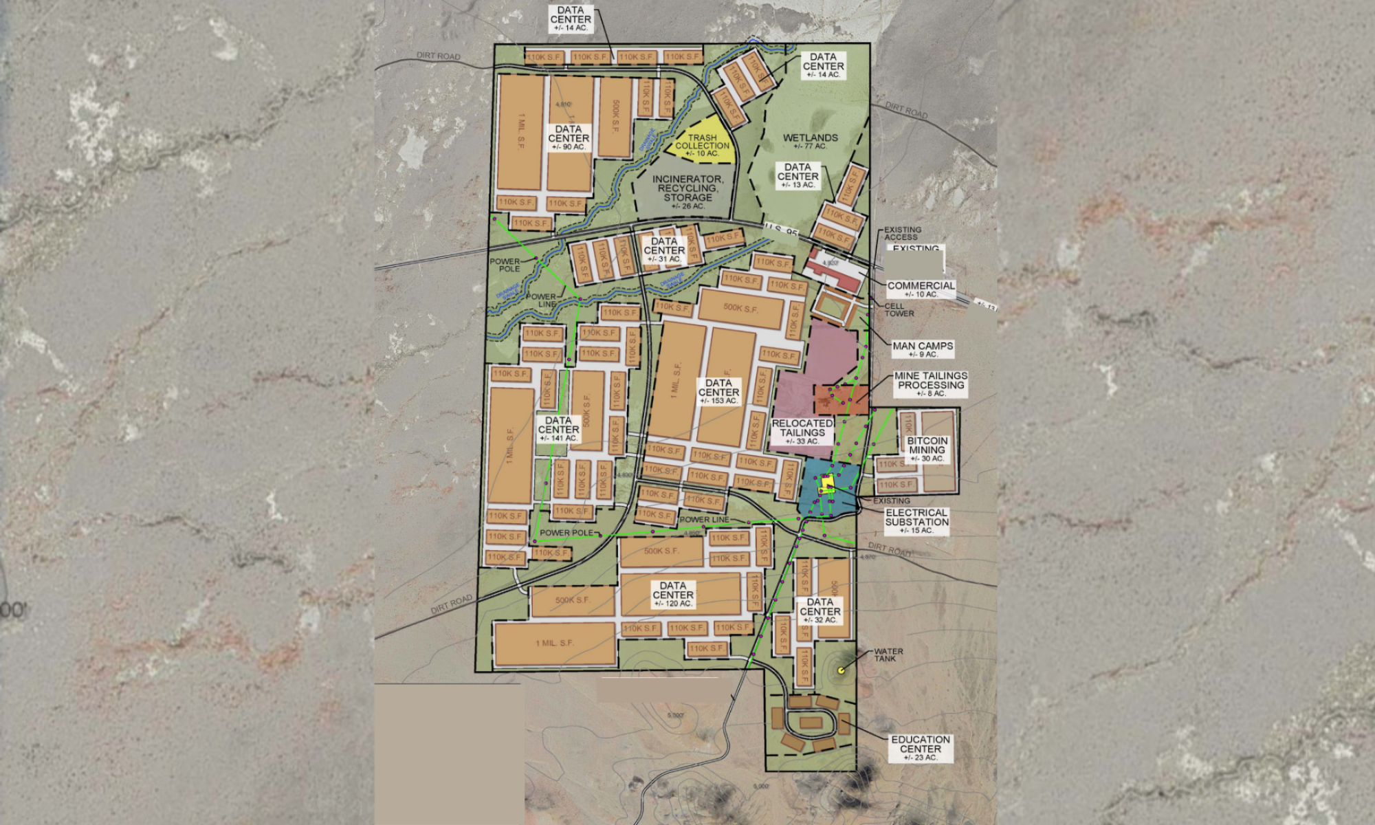
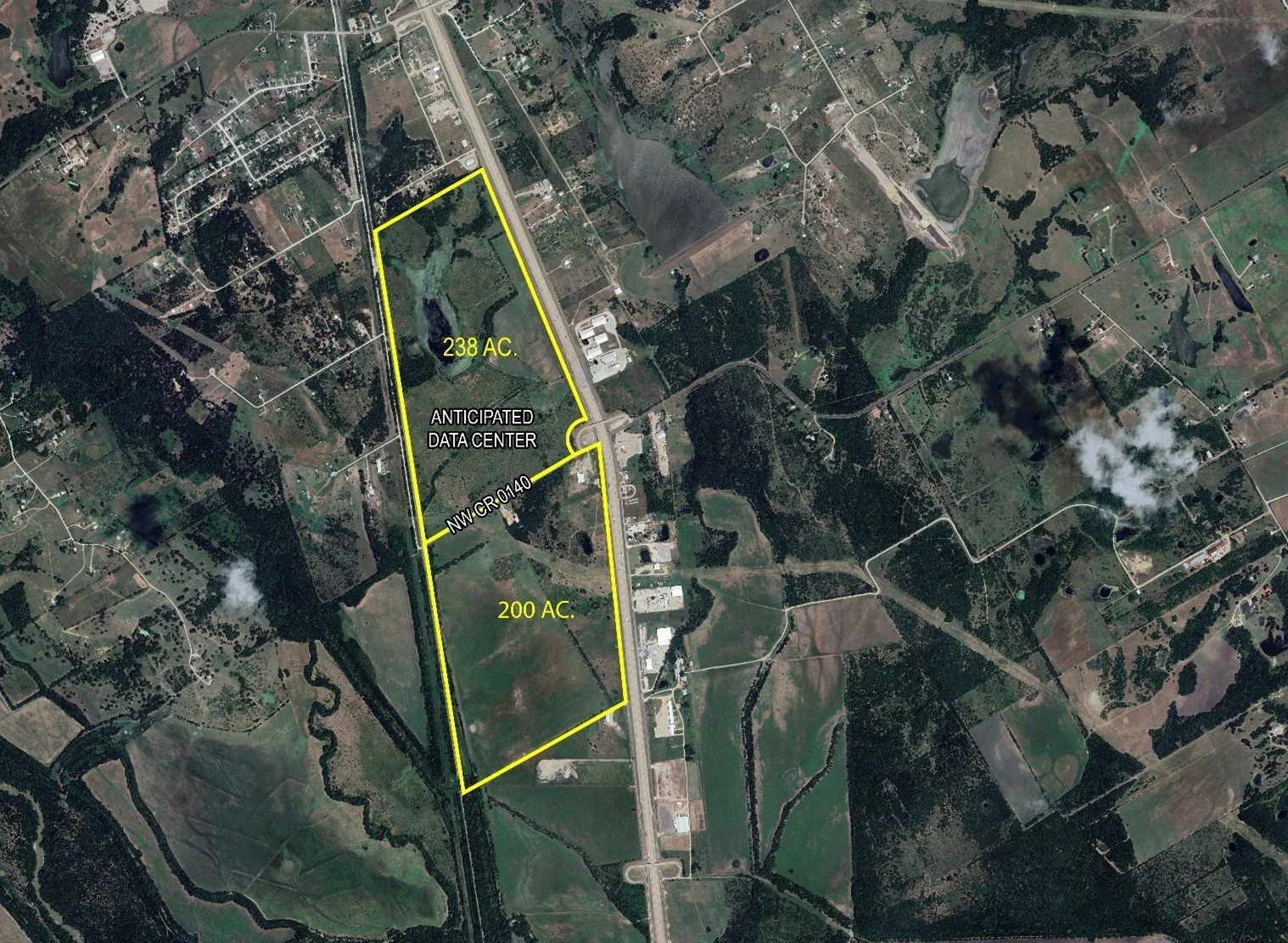
RELEVANT PROJECTS:
-
Specialized surveying for wind, solar, and utility projects. We map topography, boundaries, and easements, and provide precise construction staking using GPS and 3D scanning—ensuring accuracy, compliance, and efficient delivery from planning through construction.
RELEVANT PROJECTS:
-
R&R provides precise Utility and Right of Way (ROW) surveys critical for construction success.
Utility Surveys provide accurate mapping of underground utilities—water, gas, electric, and telecom—for safe design, construction, and regulatory compliance. Essential for avoiding conflicts and ensuring informed planning.
ROW Surveys define boundaries, easements, and zoning alignment to support land acquisition and infrastructure development. Clear, reliable data for seamless project execution.
RELEVANT PROJECTS:
-
We translate design plans into precise on-site reference points for foundations, roads, utilities, and more. Our field crews ensure horizontal and vertical accuracy, while post-construction as-builts confirm alignment with project specs and regulations.
RELEVANT PROJECTS:
-
Comprehensive surveys for commercial transactions, providing detailed insight into boundaries, easements, and site improvements. Trusted by lenders and title companies to ensure clear, accurate property data.
RELEVANT PROJECTS:
-
Our surveys map natural and built features, providing accurate elevations and contours to guide planning. We tailor design surveys to the unique needs of each project—ensuring every detail supports safe, efficient, and well-integrated development.
Topographic surveys provide accurate mapping of a site’s natural and built features, including elevation, contours, and surface conditions. This foundational data supports informed design and efficient site planning.
Design surveys are project-specific surveys that build on topographic data to support layout, grading, and engineering decisions. Designed to align development plans with site conditions, codes, and performance goals.
RELEVANT PROJECTS:
-
Underwater mapping for safe navigation and informed development. Using sonar technology, we chart depths, terrain, and submerged features—essential for marine construction, environmental studies, and hazard avoidance.
RELEVANT PROJECTS:
-
Foundational surveys for real estate and development—establishing clear property lines, mapping land divisions, and supporting accurate transactions and safe construction.
Boundary Surveys define legal property lines through precise fieldwork and records research. Essential for real estate transactions, permitting, and resolving boundary disputes.
Platting Surveys map and divide land for development. Platting defines lots, easements, and rights of way—supporting subdivisions, entitlements, and municipal approvals.
RELEVANT PROJECTS:
-
We combine 3D laser scanning and aerial photogrammetry to deliver high-accuracy site data. Using the Trimble X7 and DJI Mavic 3 drone, we capture detailed point clouds and aerial imagery—seamlessly integrated into AutoCAD, Revit, and BIM workflows for efficient, design-ready deliverables.
RELEVANT PROJECTS:


CIVIL ENGINEERING SERVICES
-
Stormwater solutions that balance performance and compliance. We design detention basins, water quality systems, and erosion controls tailored to site-specific hydrology—ensuring effective runoff management and regulatory approval.
RELEVANT PROJECTS:
-
We design reliable and sustainable utility systems tailored to each site. Our services include potable and non-potable water design, sanitary sewer planning, stormwater management, and utility coordination—backed by hydraulic and hydrologic analysis for optimized system performance.
RELEVANT PROJECTS:
-
Accurate underground utility data to reduce risk and avoid delays. We provide utility designation, mapping, conflict analysis, and coordination—ensuring efficient, conflict-free development through every phase.
RELEVANT PROJECTS:
-
Smart, sustainable solutions for streets, intersections, and multimodal mobility. We design roadways, bike and pedestrian paths, parking lots, and integrated drainage—partnering with municipalities and developers to enhance connectivity and long-term performance.
RELEVANT PROJECTS:
-
Comprehensive site evaluations to guide smart development decisions. Our civil team assesses topography, zoning, infrastructure, and environmental factors—delivering clear insights to reduce risk, support approvals, and set your project up for success.
RELEVANT PROJECTS:
-
Expert guidance through the land use approval process. We handle zoning analysis, application prep, agency coordination, and public hearing representation—ensuring your project meets regulations and moves forward with confidence.
RELEVANT PROJECTS:
-
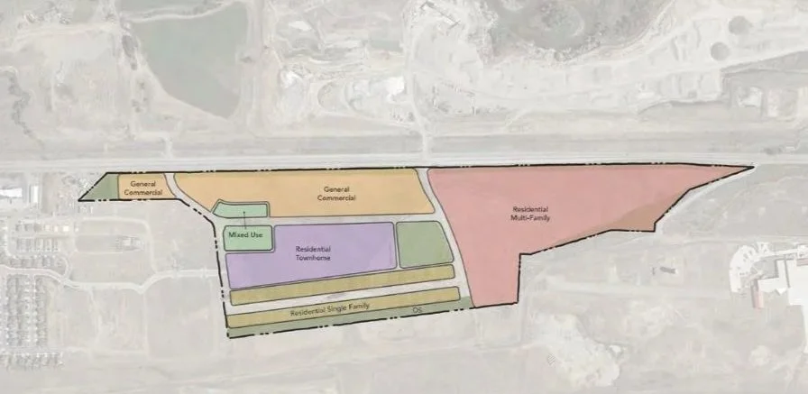
Strategic planning to maximize land use and ensure project viability. We evaluate site constraints, design functional layouts, plan infrastructure, and guide regulatory compliance—delivering smart, tailored solutions from concept to approval.
RELEVANT PROJECTS:
-
Optimized site development through precise grading design and earthwork planning. We balance cut-and-fill, integrate drainage, and design for erosion control—reducing costs, streamlining construction, and ensuring compliance from the ground up.
RELEVANT PROJECTS:


OWNER’S REPRESENTATIVE SERVICES
-
R&R Engineers-Surveyors, Inc. provides comprehensive due diligence services to support site development decisions. Our civil engineering team evaluates key factors like:
Site Analysis: Topography, soil, floodplain impacts, and easements.
Regulatory Review: Zoning, land use, and permitting compliance.
Infrastructure Assessment: Utilities, access, drainage, and more.
Environmental Review: Wetlands, habitats, species, and stormwater concerns.
We mitigate risks, streamline approvals, and deliver actionable insights, ensuring your project is built on a solid foundation of accuracy and compliance.
-
R&R Engineers-Surveyors, Inc. simplifies the land use approval process with expert Entitlement Support services, ensuring project viability and compliance. Our services include:
Zoning & Land Use Analysis: Aligning projects with zoning and land use policies.
Entitlement Applications: Preparing and submitting rezoning, subdivision, and site plan requests.
Agency Coordination: Collaborating with governing bodies to secure approvals.
Public Hearing Representation: Providing expert advocacy at hearings and meetings.
Compliance Review: Ensuring adherence to codes, standards, and regulations.
We deliver thorough analyses, clear documentation, and expert guidance to overcome regulatory challenges efficiently and achieve successful project approvals.
-
R&R Engineers-Surveyors, Inc. specializes in Grading & Earthwork Analysis services for efficient site development and compliance with design requirements. Our civil engineering team delivers precise evaluations and solutions tailored to the unique topographical and soil conditions of each project site, streamlining the construction process and reducing unexpected challenges.
Services include:
Site Grading Design: Optimize drainage, infrastructure, and building layouts.
Earthwork Quantification: Balance cut-and-fill volumes to reduce costs and environmental impact.
Erosion Control Planning: Prevent site degradation and protect surrounding areas.
Drainage Integration: Coordinate grading with stormwater systems to manage runoff effectively.


Our team of Licensed Professionals cover multiple
states throughout the nation.

Tailored Services to Move Your Project Forward.
Every successful project starts with a clear vision—and the right team to bring it to life. At R&R, we support that vision through The R&R Way: a thoughtful, streamlined approach rooted in precision, partnership, and purpose. From surveying and site planning to utility design, entitlement support, and construction layout, our integrated services are built to move your project forward—efficiently and confidently. Tell us about your project—we’ll take it from there.