

R&R SERVICES
LAND SURVEYING & CONSTRUCTION STAKING
-
3D Laser Scanning use the Trimble X7 to capture high-definition 3D point clouds with speed and precision. This cutting-edge tool integrates seamlessly with AutoCAD, Revit, and BIM software—saving time and reducing rework through accurate, design-ready data.
Aerial Photogrammetry uses our DJI Mavic 3 drone, we collect precise aerial imagery to create 3D models, topographic maps, and elevation data. Ideal for large or complex sites, this method enables efficient measurement, monitoring, and mapping from above.
Discover how aerial photogrammetry can elevate your next project.
RELEVANT PROJECTS:
-
Specialized surveying for wind, solar, and utility projects. We map topography, boundaries, and easements, and provide precise construction staking using GPS and 3D scanning—ensuring accuracy, compliance, and efficient delivery from planning through construction.
RELEVANT PROJECTS:
-
R&R provides precise Utility and Right of Way (ROW) surveys critical for construction success.
Utility Surveys provide accurate mapping of underground utilities—water, gas, electric, and telecom—for safe design, construction, and regulatory compliance. Essential for avoiding conflicts and ensuring informed planning.
ROW Surveys define boundaries, easements, and zoning alignment to support land acquisition and infrastructure development. Clear, reliable data for seamless project execution.
RELEVANT PROJECTS:
-
We translate design plans into precise on-site reference points for foundations, roads, utilities, and more. Our field crews ensure horizontal and vertical accuracy, while post-construction as-builts confirm alignment with project specs and regulations.
RELEVANT PROJECTS:
-
Comprehensive surveys for commercial transactions, providing detailed insight into boundaries, easements, and site improvements. Trusted by lenders and title companies to ensure clear, accurate property data.
RELEVANT PROJECTS:
-
Our surveys map natural and built features, providing accurate elevations and contours to guide planning. We tailor design surveys to the unique needs of each project—ensuring every detail supports safe, efficient, and well-integrated development.
Topographic surveys provide accurate mapping of a site’s natural and built features, including elevation, contours, and surface conditions. This foundational data supports informed design and efficient site planning.
Design surveys are project-specific surveys that build on topographic data to support layout, grading, and engineering decisions. Designed to align development plans with site conditions, codes, and performance goals.
RELEVANT PROJECTS:
-
Underwater mapping for safe navigation and informed development. Using sonar technology, we chart depths, terrain, and submerged features—essential for marine construction, environmental studies, and hazard avoidance.
RELEVANT PROJECTS:
-
Foundational surveys for real estate and development—establishing clear property lines, mapping land divisions, and supporting accurate transactions and safe construction.
Boundary Surveys define legal property lines through precise fieldwork and records research. Essential for real estate transactions, permitting, and resolving boundary disputes.
Platting Surveys map and divide land for development. Platting defines lots, easements, and rights of way—supporting subdivisions, entitlements, and municipal approvals.
RELEVANT PROJECTS:
-
We combine 3D laser scanning and aerial photogrammetry to deliver high-accuracy site data. Using the Trimble X7 and DJI Mavic 3 drone, we capture detailed point clouds and aerial imagery—seamlessly integrated into AutoCAD, Revit, and BIM workflows for efficient, design-ready deliverables.
RELEVANT PROJECTS:


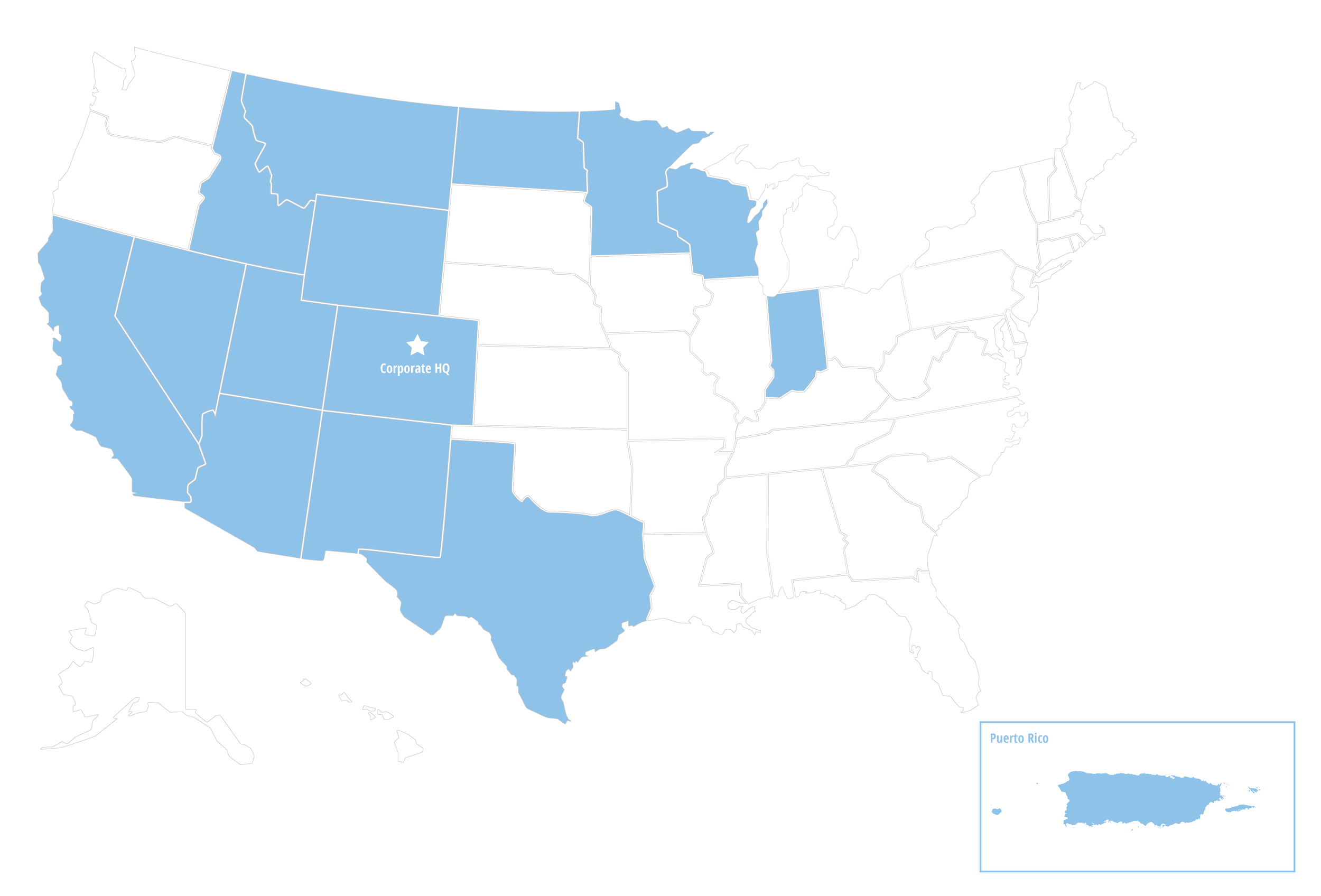
Our team of Licensed Professionals cover multiple
states throughout the nation.
Tailored Services to Move Your Project Forward.
Every successful project starts with a clear vision—and the right team to bring it to life. At R&R, we support that vision through The R&R Way: a thoughtful, streamlined approach rooted in precision, partnership, and purpose. From surveying and site planning to utility design, entitlement support, and construction layout, our integrated services are built to move your project forward—efficiently and confidently. Tell us about your project—we’ll take it from there.